
After taking a slow, horseshoe-shaped dip across eastern Cuba over the past 36 hours and dumping over a foot of heavy rain – causing pockets of significant flooding – poorly-organized Oscar is picking up the pace and accelerating through the southeastern Bahamas and toward the western Atlantic.
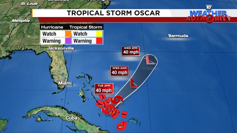
Oscar is rapidly losing its tropical characteristics and will be absorbed by a cold front advancing into western Atlantic waters over the next day or two. The only lingering effects will be blustery downpours and localized flooding for today across the southeastern Bahamas and Turks and Caicos.
Quiet behind Oscar this week, but returning to the Caribbean later next week
Behind Oscar, the tropical Atlantic will take a pause until at least the early part of next week.
As we’ve discussed in newsletters since last week, one last gasp may be in store for the Atlantic as we turn the calendar to November. Long-range models are advertising a decent development signal in the central Caribbean starting around Wednesday to Friday next week (October 30th to November 1st).

If you have interests or travel plans to the Caribbean later next week, it’s something to monitor, but for now it’s too far out to speculate what may come of it.
The typical date for the last named storm formation in the Atlantic is November 7th, so we’d anticipate at least one more named storm before the season draws to a close. That said, of the 386 known hurricanes to have struck the U.S., only 5 did so after October – unnamed hurricanes in 1861 and 1935, Kate in 1985, Wrong-Way Lenny in 1999, and most recently Nicole in 2022. That means historically 99% of U.S. hurricane landfalls (including the territories) happen before November.
Hostile wind shear has consumed the mainland U.S. and models don’t show that abating into early November, which is a positive if anything forms later next week. We’ll watch the trends but for now there’s no need for us to worry about any threats in the near-term stateside.
Copyright 2024 by WPLG Local10.com - All rights reserved.
