
Hurricane Ernesto continued to churn northward toward Bermuda on Friday, with its large, outer circulation bringing gusty winds already nearing tropical storm strength to parts of the archipelago on Friday morning.
Conditions will deteriorate quickly today as the core of the dangerous Category 2 hurricane is forecast to move over or near Bermuda by early Saturday.

A prolonged period of tropical storm winds will begin today in Bermuda and continue through Saturday night, with winds gusting to above 100 mph during Ernesto’s closest pass on Saturday. A considerable flash flood threat is expected with more than 15 inches of rain forecast over the next day or two. Significant storm surge and coastal flooding will also accompany the hurricane as it approaches Bermuda, worsened by large and battering waves at the shoreline.

Though Ernesto will remain well east of the mainland United States, long-period swell from the large hurricane will reach the southeastern U.S. coastline today and propagate up the Eastern Seaboard this weekend. This will create extremely dangerous marine and beach conditions over the next several days, with a high risk for life-threatening rip currents along most east and south-facing beaches stretching from Florida to New England.
This surf zone threat will extend into early next week as 5-to-7-foot waves scour out new channels in sandbars for potentially deadly rip currents. Those spending time along east coast beaches this weekend will generally want to avoid the rough and inhospitable ocean over the coming days.
What’s Ernesto looking like right now?
Ernesto is a big hurricane, with its zone of maximum winds located some 50 miles from its center. For most hurricanes, we expect a radius of maximum winds on the order of 15-25 miles, so Ernesto is about twice the size of your run-of-the-mill hurricane. All else equal, bigger hurricanes carry more energy and a large Category 2 hurricane can be more destructive than some Category 4 hurricanes.
Although Ernesto has steadily strengthened, it’s become more ragged in appearance today and is struggling to close off an eyewall – the ring of storms that immediately surround the hurricane’s eye. Hurricane hunters Friday morning reported an open eyewall on its western side, which was also evident on an earlier microwave satellite pass.
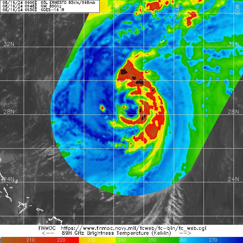
The ill-formed eyewall will continue to allow drier air from outside the core to mix into its interior, likely arresting Ernesto’s development today. Ernesto is battling noticeably higher wind shear from the west than what forecast models had anticipated, which has thankfully kept it from quickly strengthening.
The unforeseen wind shear will probably cap Ernesto’s intensity, especially if its eyewall is unable to close off in the hours ahead. Nevertheless, the hurricane will be the most serious threat that Bermuda has faced from a hurricane since Paulette in September 2020.
All quiet for now behind Ernesto
As we mentioned in Thursday’s newsletter, forecast models are surprisingly silent into next week across the Atlantic. Despite a conducive upper-level wind configuration and reduced wind shear, the tropical waves pushing off Africa are hitting the Atlantic at a higher latitude than typical. This is allowing lingering dryness from the waning Saharan Air Layer to limit their thunderstorm growth and stave off development odds for now.

So expect an overall quiet week behind Ernesto in the Atlantic. In late August, quiet weeks don’t come often, so we’ll enjoy the unexpected reprieve.
Copyright 2024 by WPLG Local10.com - All rights reserved.
