
The mostly “dry” tropical disturbance moving through the Atlantic that we first brought to your attention in this newsletter a week ago is slowly gathering storminess as it moves through the islands of the northeastern Caribbean this morning.

Where and when exactly the scattered storms coalesce within the broader tropical wave over the next few days will be crucial to how the forecast plays out late week into the weekend.
Lingering questions remain on whether a weaker system slips through South Florida into the eastern Gulf of Mexico or a more coherent tropical storm turns east of Florida and tracks alongside the southeast U.S.
What we know now
The next few days we’re confident on a westward trajectory near or north of the Caribbean islands toward the southeastern Bahamas and eastern Cuba by Friday. We expect a slow increase in thunderstorm activity and at most an organizing tropical system (tropical depression or low-end tropical storm) by the end of the work week.

While the disturbance will bring blustery weather and intermittent downpours to the northern Caribbean islands – including Puerto Rico and the U.S. Virgin Islands later today and on Thursday – a significant tropical threat isn’t expected for these areas.
Due to the disorganized nature of the storminess, development will be a gradual process.
Does the system slip west into Florida or turn east of Florida?
As we discussed in yesterday’s newsletter, how organized the disturbance becomes before reaching the Bahamas is crucial to whether it affects our weather in South Florida this weekend or turns to our east, keeping us on its drier western side this weekend.
How the system interacts with the complicated terrain of the Caribbean islands will play a pivotal role in its downstream development. This evolution isn’t something handled very well by our forecast models, which is why we see a large spread in the possible scenarios this weekend into early next week.
Regardless, however, we anticipate a bend to the north by Saturday as the system nears Florida. Models continue to suggest a weaker system (tropical disturbance, tropical depression, or low-end tropical storm) favoring a westward track into South Florida for Saturday into Sunday.
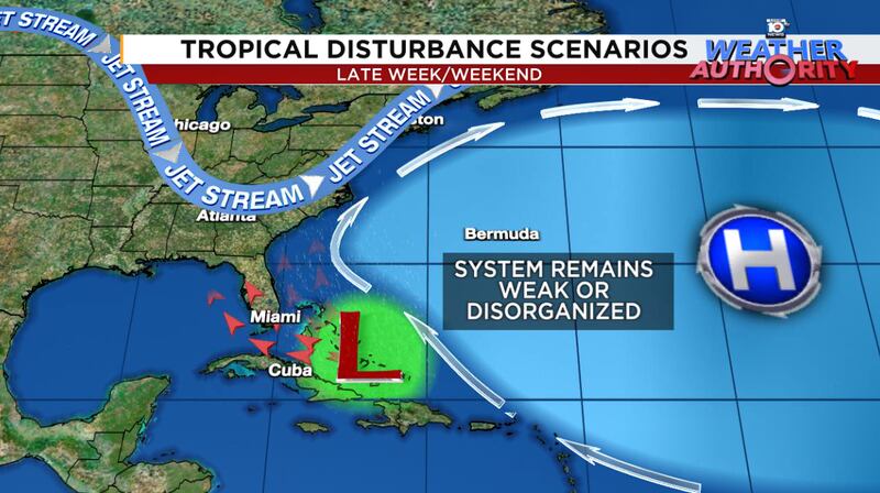
Meanwhile, a more organized storm late week would favor a turn east of Florida and moving up the southeast U.S. into early next week.

There are also credible scenarios that maintain an undeveloped tropical disturbance through South Florida and into the eastern Gulf of Mexico, where delayed development is possible into next week.

Wide bookends to the forecast
The range of possibilities is higher today than it’s been so interests from the eastern Gulf of Mexico to the Carolinas should continue to monitor the progress of the system.
The bottom line hasn’t changed for South Florida. We should expect an organizing tropical system to be on our doorstep by Saturday. If a tropical system impacts our area, it will likely come from a weaker system – a blustery tropical disturbance, tropical depression, or low-end tropical storm – Saturday into Sunday.
If the pieces come together sooner, the system may pass to our east, and a more organized tropical storm could curve east of the southeast U.S. or even affect the Carolinas.
A less ideal situation for our neighbors along the Gulf Coast is for the disturbance to stay weak and slip through Florida into the Gulf for early next week.
Still some time to watch, but those in the southeast states should stay aware this week.
Copyright 2024 by WPLG Local10.com - All rights reserved.
