
For newsletter subscribers: With tomorrow, June 1st, marking the official start of the 2024 Atlantic hurricane season, today we resume the daily Talking Tropics newsletter. The goal of the newsletter is to alert you first to any signs of tropical trouble in the Atlantic. On days when the Atlantic is less active, we’ll share unique insight and expert analyses about the developing season you won’t find anywhere else. The newsletter arrives in your inbox first thing each weekday morning (and on weekends, as conditions warrant) throughout hurricane season. Thank you for your ongoing support and readership.
On the eve of the official start of the 2024 Atlantic hurricane season, the pre-season hurricane predictions are in.
Of the two dozen or so government, academic, and private groups that forecast seasonal hurricane activity, all are predicting above-average activity for the Atlantic in 2024, according to seasonalhurricanepredictions.org, an online aggregator of seasonal hurricane predictions and hurricane activity.
Both government forecasters and the pioneers of seasonal forecasting at Colorado State University are predicting a hyperactive hurricane season in 2024, issuing their highest forecast numbers ever, with overall seasonal activity rivaling record seasons like 2004, 2005, 2010, and 2017.
Needless to say, there’s a lot of hype surrounding this hurricane season, so what should (or shouldn’t) we expect?
Early activity isn’t a harbinger for the rest of the season unless...
Eight of the past ten years have recorded the first Atlantic tropical or subtropical storm before the traditional June 1st start of the season. Five pre-season storms during that period – Ana in 2015, Bonnie in 2016, Alberto in 2018, and Arthur and Bertha in 2020 – affected the United States. These early starts even prompted a recommendation from the World Meteorological Organization to the NHC in 2021 to assess moving back the hurricane season start from June 1st to May 15th (NHC ultimately decided to keep the June 1st start).
As we’ve written in previous newsletters, early starts or a flurry of activity early in the hurricane season doesn’t have any meaningful relationship with overall seasonal activity – that is, unless the early storms happen far out in the deep tropical Atlantic. Specifically, researchers have found that named storms forming in June and July in the band of waters east of the Caribbean to Africa indicates an active hurricane season is likely.
While the opposite isn’t true – little or no early season activity in the deep Atlantic doesn’t portend a quiet season – we’ll be watching to see if the east Atlantic perks up sooner than we might expect.
More activity doesn’t always mean more landfalls but...
There’s a weak relationship between the total number of hurricanes and total hurricane landfalls. In short, more hurricanes overall can lead to more landfalls, but it usually isn’t a big factor – unless it’s a very active hurricane season.
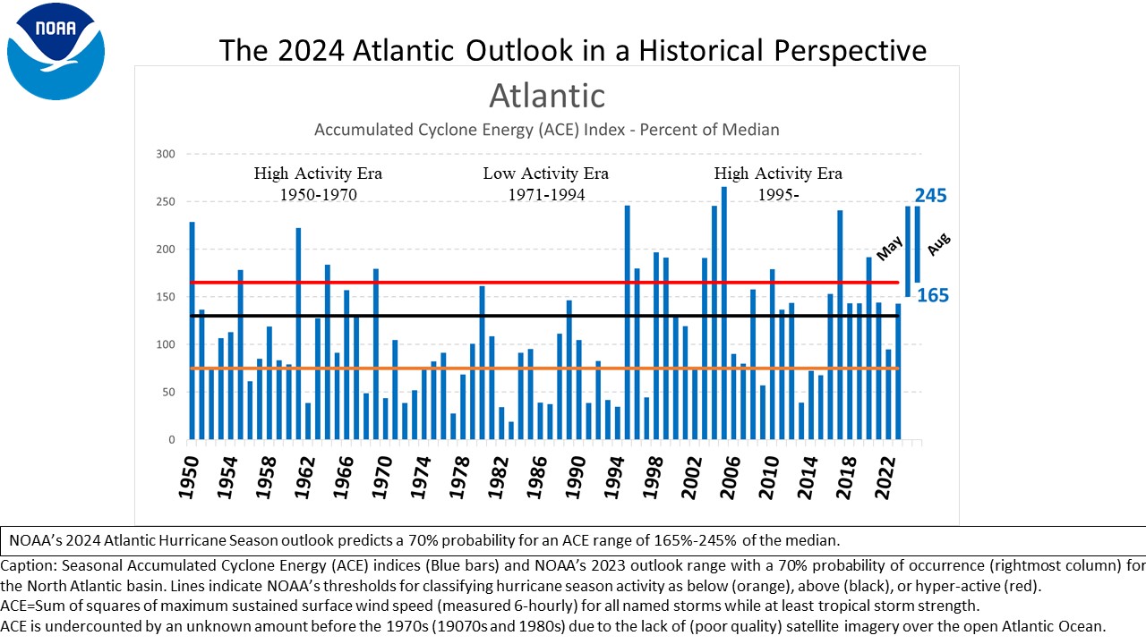
Colorado State University is currently forecasting a total ACE – the scorecard of seasonal activity – of 210 for the Atlantic (the 30-year average is 123). According to CSU lead forecaster Dr. Phil Klotzbach, “We have observed eight 200-plus ACE seasons on record: 1893, 1926, 1933, 1950, 1995, 2004, 2005 and 2017. All of these years had three or more landfalling hurricanes, and all but 1995 had two or more major (Category 3 or stronger) hurricane landfalls. And whatever 1995 lacked in buffeting the continental U.S., it made up for with Caribbean wrath, with both Luis and Marilyn that year hammering the Lesser Antilles.”
Years with more than 10 Atlantic hurricanes have averaged twice the number of mainland U.S. landfalls per year than those seasons with fewer than 10 total hurricanes (3 vs. 1.5 mainland U.S. landfalls). So while there have been very active seasons like 2010 (with an ACE of 165) in which we’ve had no U.S. hurricane landfalls, 2010 is the exception, not the rule, and in general very busy seasons see more landfalling hurricanes.
We need the Atlantic to simmer down
There’s a lot more to hurricanes than warm ocean waters, but sea surface temperatures have an outsize impact on hurricane development and seasonal activity. It’s the warm water that drives the hurricane heat engine. Sea surface temperatures matter more than any other seasonal factor – including whether we’re in an El Niño or La Niña.
Although El Niño conditions in the eastern Pacific – abnormally warm waters around the equator – can shut down Atlantic storm development with prohibitive wind shear, when the Atlantic is exceptionally hot, as was the case in 2023 with a raging El Niño, it doesn’t matter so much.
We’re headed into the 2024 Atlantic hurricane season with the warmest tropical Atlantic on record – and by a wide margin.
Last year we had El Niño working in our favor, but we’re quickly transitioning to a full-fledged La Niña for the peak months of the season, which usually reduces storm-busting wind shear, especially closer to the U.S.
Though forecast models don’t foresee it happening, we need the Atlantic to simmer down.
All the pre-season hype shouldn’t affect your preparedness plans
We’re all understandably interested in how the season shapes up, but big, bad hurricanes can happen in any season – active or not. South Floridians know this well after Andrew, the first named storm of 1992 and only U.S. hurricane landfall during an otherwise ho-hum hurricane season.
The good news is social science research has found the public generally doesn’t change its level of preparedness based on seasonal hurricane predictions.
You should always know whether you live in a hurricane evacuation zone and where you plan to go if evacuations are called for your area. Since most evacuation zones are based on the coastal storm surge threat, you typically don’t have to travel far to escape the water threat, historically the biggest killer of a hurricane.
Check back often this hurricane season, especially in August, September, and October when big hurricanes are most common. As recent history has shown, intense hurricanes can form fast. Every Category 5 hurricane that’s struck the mainland U.S. in the past 100 years was a tropical storm or weaker only 3 days before landfall. That’s not a lot of time to prepare, so use the quiet early days to your advantage.
We expect 2024 will bring its own surprises, but we also expect a little vigilance and early planning will help South Floridians weather the season, whatever comes.
For now, the Atlantic looks to start the season on a quiet note, but when that changes, you’ll be the first to know.
WATCH SPECIAL: Weather Authority presents Staying Storm Safe in Hot Water
