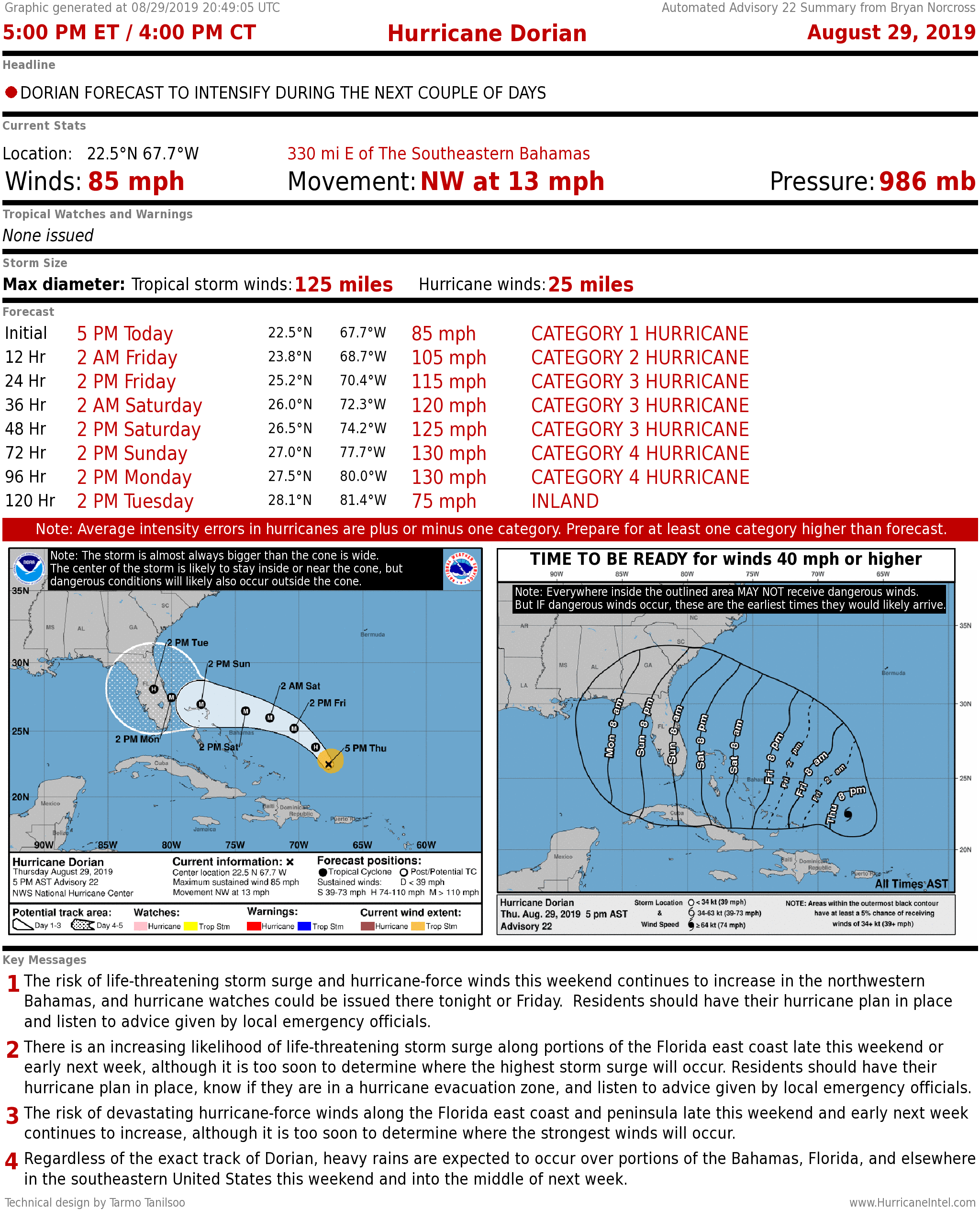
MIAMI – The computer forecast models continue to give confusing signals about where Hurricane Dorian is going to impact the Florida coast. But a very strong hurricane – Category 4 plus or minus – is still forecast to impact the state.
At 5 p.m., Dorian was packing 85 miles per hour winds and traveling Northwest at 13 mph.
The computer forecast models and the official National Hurricane Center forecast show Hurricane Dorian slowing down significantly as the approaches Florida. The afternoon models still show a wide range of possibilities for the evolution of the weather pattern over Florida, and how it will steer the hurricane. The main take-away is that the hurricane is expected to move very slowly when it gets to the vicinity of Florida.
CLICK HERE to have the Bryan Norcross Talks Tropics newsletter delivered to your inbox
This slow movement has a lot of bad ramifications: Storm surge at the coast and in bays and rivers will be higher because the storm has more time to pile up water. This on top of the King Tides, which already are a foot or more higher than normal water levels. In addition, the flooding threat from heavy rain is drastically enhanced, as with Hurricane Florence last year. About a foot of rain is the current forecast, but that is subject to change.
There is high confidence that Dorian is going to eventually turn to the north. The unknown is where that turn will take place. The National Center Forecast shows the turn happening over or very near the Florida peninsula in South Florida.
For your scheduling, the “Time to Be Ready” is now set for Saturday overnight, so with the current forecast, all day Saturday would be available for preparing.
Hurricane Dorian is reorganizing temporarily, but significant intensification is still expected to continue soon. It’s currently about 800 miles from Miami.
The forecast is fairly straightforward for the next couple of days. The storm is very likely to move northwest until it bumps into a strong, blocking high pressure area. That high will deflect it to the west in the direction of Florida. In addition, Dorian will grow in size on its trek west.
There are no obvious large-scale impediments in Dorian’s path. Upper-level winds are generally favorable for strengthening and the ocean water is very warm, especially when it gets near Florida.
People in the Northwestern and Central Bahamas – especially on Grand Bahama and Abaco – should stay in close touch with local instructions and forecasts. Hurricane Watches will be issued for parts of the Bahamas tonight or tomorrow.
As Dorian approaches Florida, the influence of the blocking high, which is driving it west, will begin to diminish. This is expected to slow the forward progress of the storm meaning a strong, slow-moving hurricane is expected to be in the vicinity of Florida late in the holiday weekend. There is also the possibility of Dorian essentially stalling near or over the state.
Do not focus on the points in the center of the National Hurricane Center cone. Reliable computer forecast models show Dorian coming to South Florida, and others show it much farther north.
In most scenarios, much of Florida will feel significant affects from the storm, and areas outside of the current cone to the north will likely feel effects as well.
CLICK HERE to download the FREE Max Tracker App for real-time storm information
The bottom line is that everybody in Florida needs a plan now. Quick action will be required Friday or over the weekend on the current schedule. Here are a few immediate things you can do, while you get ready to execute your hurricane plan.
- Fill Ziploc-type plastic bags ¾ full of water and stuff them in every corner of your freezer. You want them to freeze while you have electricity. It might take a couple of days for them to freeze. Nothing is lost if you don't get the storm.
- Fill up with gas.
- Get cash.
- Fill your prescriptions.
- Wash your clothes and dishes.
- Take photos of every room and the outside of your house. Upload them to the cloud or email them to yourself in Gmail, Hotmail, etc.
- Also take photographs of important papers and contact information. Upload or email those photos as well.
None of those actions cost anything, so there is no reason not to get them out of the way. Obviously, the sooner you buy hurricane supplies, clean up your yard and get your important papers organized, the better, as well.
The key messages from the National Hurricane Center are:
1. The risk of life-threatening storm surge and hurricane-force winds this weekend continues to increase in the northwestern Bahamas, and hurricane watches could be issued there tonight or Friday. Residents should have their hurricane plan in place and listen to advice given by local emergency officials.
2. There is an increasing likelihood of life-threatening storm surge along portions of the Florida east coast late this weekend or early next week, although it is too soon to determine where the highest storm surge will occur. Residents should have their hurricane plan in place, know if they are in a hurricane evacuation zone, and listen to advice given by local emergency officials.
3. The risk of devastating hurricane-force winds along the Florida east coast and peninsula late this weekend and early next week continues to increase, although it is too soon to determine where the strongest winds will occur.
4. Regardless of the exact track of Dorian, heavy rains are expected to occur over portions of the Bahamas, Florida, and elsewhere in the southeastern United States this weekend and into the middle of next week.
Elsewhere, no tropical systems are expected to develop through the Labor Day weekend.

