
Tropical Storm Bret continued to slowly gather steam overnight some 700 miles east of the easternmost Caribbean islands.
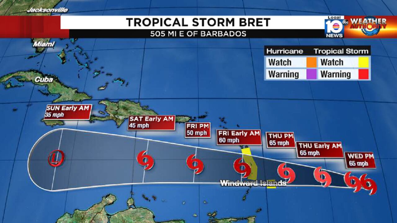
As of 5 AM ET Wednesday, Bret’s maximum winds had increased to 60 mph and late Tuesday, Tropical Storm Watches were issued for Barbados, Dominica, Martinique and St. Lucia in the Lesser Antilles.
A Tropical Storm Watch means winds of 39 to 73 mph are possible within the next 48 hours. These watches will likely be upgraded to warnings later today, as the storm nears the islands on Thursday.
Bret’s overall appearance remains disheveled as it’s embedded within typically strong June trade wind flow across the deep tropical Atlantic.
These brisk east-to-west flowing low-level winds are a common climatological impediment to tropical activity in the main development region east of the Caribbean prior to July and August. The strong trade winds enhance vertical wind shear – the change in wind speed or direction with height – early in the season, especially at the middle part of the atmosphere, which has served as a roadblock to Bret’s rate of strengthening.

By August and September, the trade winds relax significantly, and the forward motion of developing storms slows, allowing for heightened tropical activity in the main development region of the Atlantic for the hurricane season peak.

Bret has a narrow window to maintain its current strength or perhaps strengthen slightly before it moves into the teeth of much stronger wind shear.
The National Hurricane Center forecasts Bret to be a 60 to 65 mph tropical storm as it moves through the Lesser Antilles Thursday into the early morning hours on Friday. Bret’s strongest winds will be confined to the area near and north of its center.
Air Force Hurricane Hunters are scheduled to begin investigating the system early this afternoon.
By late Friday and Saturday, Bret will get quickly shredded by the southern portion of the subtropical jet stream as it tracks well south of Puerto Rico and the U.S. Virgin Islands.
Its circulation is forecast to unravel by late weekend as its remnants move into the western Caribbean. Bret isn’t expected to be a threat to South Florida or the broader U.S.
Behind Bret, we continue to monitor Invest 93L in the eastern Atlantic which could become a tropical depression by later today or on Thursday.
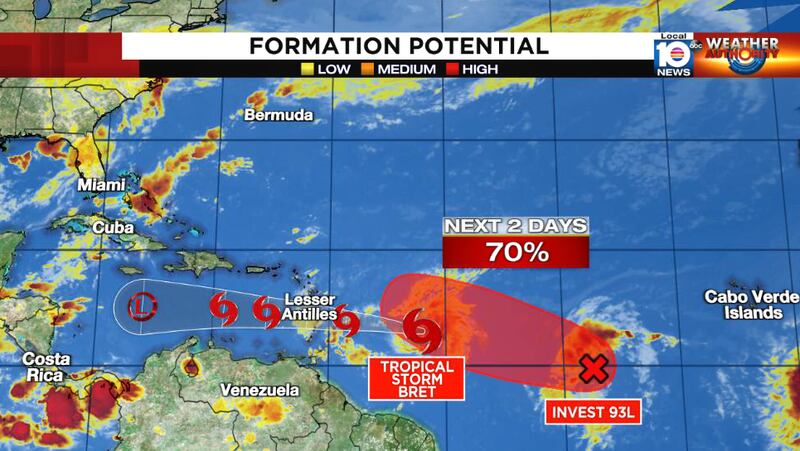
Computer models indicate 93L should move northwestward into a weakness on the western side of the subtropical high, keeping the system north of the Caribbean.
For now, 93L poses no immediate threat to land.

Copyright 2023 by WPLG Local10.com - All rights reserved.
